Flood threat through Monday morning.
7-12-25. 3:30pm This Update is brought to you by Davy Ranch Supply. We have an extensive supply of fencing materials including barbed and netting wire, t-posts, cedar and treated posts, brace and twist pipe, staples, clips, and welded panels. We also stock 7 different types of medium and heavy-duty gates ranging in length from 4 ft-20 ft. We sell galvanized portable panels and 24 ft free-standing pipe panels, too. We have concrete and poly water troughs in various sizes along with a selection bunk and hay feeders. www.davyranchsupply.com
Another MCV (mesoscale convective vortex) has formed in west Texas, thanks to an upper level trough and a cold front in the Panhandle. These storms will slowly work their way SE over the next 12-24hrs, giving most of south-central Texas, especially the western and northern counties, a good chance for scattered storms…some of which could drop some heavy rain. The scariest part of this forecast is that the best odds for rain may occur tonight and tomorrow night. As I have mentioned many times before, your best friend when it comes to severe weather threats is a NOAA weather radio. Most of the newer radios will send out an alert when warnings are present for your location. Many of us silence our phones at night and as we saw last week, being caught off guard when floods or tornadoes are present, can be deadly.
Here is what the NWS has to say about this potential heavy rain threat:
.KEY MESSAGES...

- Confidence increasing for a heavy rain threat this weekend, Flood
Watch in effect through 7 PM Sunday evening.

- Level 2 of 4 risk of excessive rainfall for today and tomorrow.

- Chances highest across portions of Central Texas, including the
Austin metro, the Hill Country, Southern Edwards Plateau, and Val
Verde County.

- Trending drier mid to late next week.
This Update is brought to you by Davy Ranch Supply. We have an extensive supply of fencing materials including barbed and netting wire, t-posts, cedar and treated posts, brace and twist pipe, staples, clips, and welded panels. We also stock 7 different types of medium and heavy-duty gates ranging in length from 4 ft-20 ft. We sell galvanized portable panels and 24 ft free-standing pipe panels, too. We have concrete and poly water troughs in various sizes along with a selection bunk and hay feeders. www.davyranchsupply.com

3:30pm radar update.
The latest NWS update on this flood threat. Click on images to see them larger.


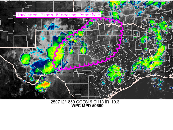
Mesoscale Precipitation Discussion 0660
NWS Weather Prediction Center College Park MD
305 PM EDT Sat Jul 12 2025
Areas affected...TX
Concerning...Heavy rainfall...Flash flooding possible
Valid 121904Z - 130104Z
Summary...Expanding convection ahead of an MCV will result in
isolated to scattered flash flooding through the afternoon across
much of central to northern Texas.
Discussion...Two distinct MCVs are evident on visible satellite
imagery...one across portions of western OK and another over the
southern TX Panhandle. It is the latter one that will likely be
the main player in an expanding thunderstorm threat over central
and north TX this afternoon and evening. These are small scale
features that can be difficult for models to resolve with much
lead time, thus not too surprising that recent high res model runs
are not doing a great job with the ongoing activity and evolution going forward.


The latest HRRR short-range model forecast for rainfall through Sunday night.
