More flooding on the way today.
7-13-25. 8:30am This Update is brought to you by Synergy Standby Solutions. Synergy Standby Solutions is a trusted provider of sales, maintenance, repairs, and fueling services for standby generators in South Central Texas. We specialize in ensuring your backup power systems remain reliable and fully operational, giving you peace of mind during power outages. With a commitment to excellence and customer satisfaction, our expert team is ready to handle all your generator needs. Learn more at www.synergystandby.com.
As I look at the radar this morning, the only good thing I’m seeing is that this storm complex will be impacting the Hill Country during the day instead of the middle of the night. I hope everyone has their weather radios and emergency apps on and is not anywhere near a flood zone. There are already flood warnings happening and this just came in for the Guadalupe River near Hunt:
FLOOD WARNING NOW IN EFFECT UNTIL TOMORROW MORNING... * WHAT...Moderate flooding is forecast. * WHERE...Guadalupe River at Hunt. * WHEN...Until tomorrow morning. * IMPACTS...At 15.0 feet, Moderate lowland flooding puts a few feet of water over the Highway 39 bridge near Hunt. Numerous secondary roads and bridges are flooded and very dangerous. * ADDITIONAL DETAILS... - At 7:50 AM CDT Sunday the stage was 8.0 feet. - Bankfull stage is 10.0 feet. - Forecast...The river will rise above flood stage this morning to 14.6 feet this afternoon. It will then fall below flood stage this evening to 9.2 feet just after midnight tonight. It will rise to 9.5 feet tomorrow morning. It will then fall again and remain below flood stage. - Flood stage is 10.0 feet. - Flood History...This crest compares to a previous crest of 14.9 feet on 10/09/2018.
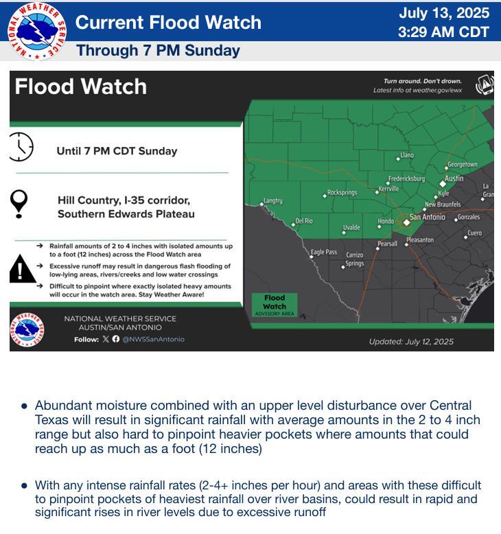
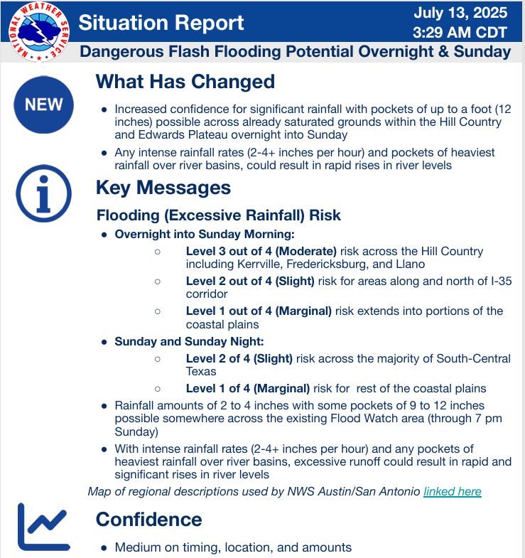
From the NWS: - A dangerous risk with potential of high impact flash flooding is forecast for Sunday. Level 3 of 4 risk of excessive rainfall Sunday morning for parts of the southern Edwards Plateau and Hill Country; a Level 2 of 4 risk along the I-35 corridor and/or near the Rio Grande - Rainfall amounts of 2 to 4 inches with isolated 9 to 12 inches possible across the Flood Watch area through Sunday evening. Rapid river rises are anticipated with this dangerous flash flooding event.
Fortunately, this system should be out of the picture by Monday and we should get back to more normal July weather by Tuesday.
Please share videos, photos and rainfall totals with us as the day progresses.
Stay safe!
Mark

This Update is brought to you by Synergy Standby Solutions. Synergy Standby Solutions is a trusted provider of sales, maintenance, repairs, and fueling services for standby generators in South Central Texas. We specialize in ensuring your backup power systems remain reliable and fully operational, giving you peace of mind during power outages. With a commitment to excellence and customer satisfaction, our expert team is ready to handle all your generator needs. Learn more at www.synergystandby.com.

8:30am radar showing lots of flood warnings (in orange) across the Hill Country. This system is slowly moving ESE.

24hr rainfall totals as of 8am.
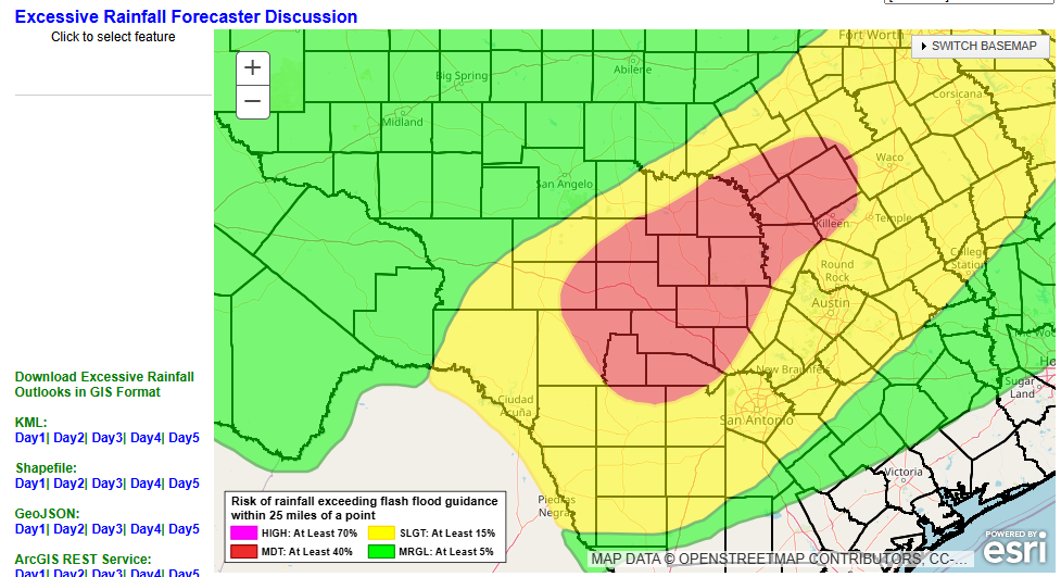
Today's risk areas for excessive rainfall.