Don’t worry about the wave…
8-13-25. 4:15pm. August and September are perfect months to get a quote from our sponsor since it takes only one tropical storm to potentially take our your power for days! This Update is brought to you by Synergy Standby Solutions. Synergy Standby Solutions is a trusted provider of sales, maintenance, repairs, and fueling services for standby generators in South Central Texas. We specialize in ensuring your backup power systems remain reliable and fully operational, giving you peace of mind during power outages. With a commitment to excellence and customer satisfaction, our expert team is ready to handle all your generator needs. Learn more at www.synergystandby.com.
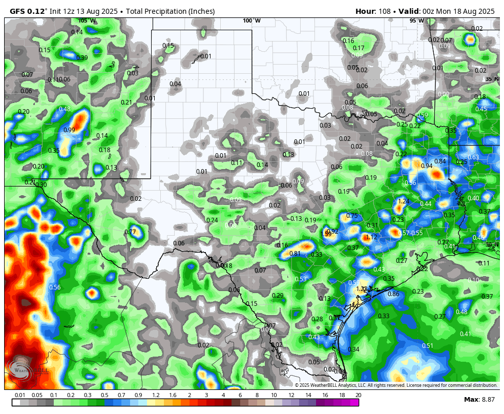
Nice to see more pm poppers this afternoon, thanks to that boundary line and weakness in the high pressure. As of post time, there are two clumps of storms…one in the San Marcos and Austin area and another in the far western Hill Country. Storms are slowly moving south and should hang around through sunset. Some spots in and around Austin have already recorded over half an inch of rain! While there could be a few more on Thursday, we will dry up through Friday before the tropical wave down in the SW Gulf moves into Mexico and brings us another chance for some scattered storms on Saturday. Best odds for rain will be along the coast and coastal plains, but as of right now, I’m not seeing any major rain totals from this.
Other than our Gulf wave, the other big tropical player is Erin, which should reach hurricane status by tomorrow. As I have mentioned all week, this storm will likely just roam over the Atlantic and not be a threat to the USA. FYI: Here is what the NHC is saying about the Gulf wave:
“Southwestern Gulf: A tropical wave over the Yucatan Peninsula is producing disorganized showers and thunderstorms. This disturbance is forecast to move west-northwestward and cross the Yucatan Peninsula today with no significant increase in organization. Some development of this system is possible after it emerges across the southwestern Gulf beginning on Thursday while it moves to the northwest at 10 to 15 mph. The system is expected to move inland over northeastern Mexico by late Friday, which should diminish its chances of development. * Formation chance through 48 hours...low...10 percent. * Formation chance through 7 days...low...10 percent.”
If some rain finds your backyard this afternoon, let us know where and how much!
Mark

August and September are perfect months to get a quote from our sponsor since it takes only one tropical storm to potentially take our your power for days! This Update is brought to you by Synergy Standby Solutions. Synergy Standby Solutions is a trusted provider of sales, maintenance, repairs, and fueling services for standby generators in South Central Texas. We specialize in ensuring your backup power systems remain reliable and fully operational, giving you peace of mind during power outages. With a commitment to excellence and customer satisfaction, our expert team is ready to handle all your generator needs. Learn more at www.synergystandby.com.

A fairly active radar this afternoon over south-central Texas! Movement of cells is slowly south.

24hr rainfall totals.

Areas that could see excessive rainfall today

Our wave will stay a wave before heading into Mexico.

Erin is gathering strength in the Atlantic.

Erin will likely have no impact to the USA.
How much rain the latest models think will fall between today and Sunday. Click on images to see them larger.