Our first “Real Front”.
10-26-25. 3:30pm. This Update is brought to you by Dietz-McLean Optical. www.dmoptical.com As a family-owned business, our independence, in house lab, great customer service and eyewear warranties, allows us to tailor your eyeglasses, lenses, and fittings: we want you to only expect the best after working with us. With six conveniently located optical shops in San Antonio, Boerne, Marble Falls and Temple, it’s easy to love what you see.
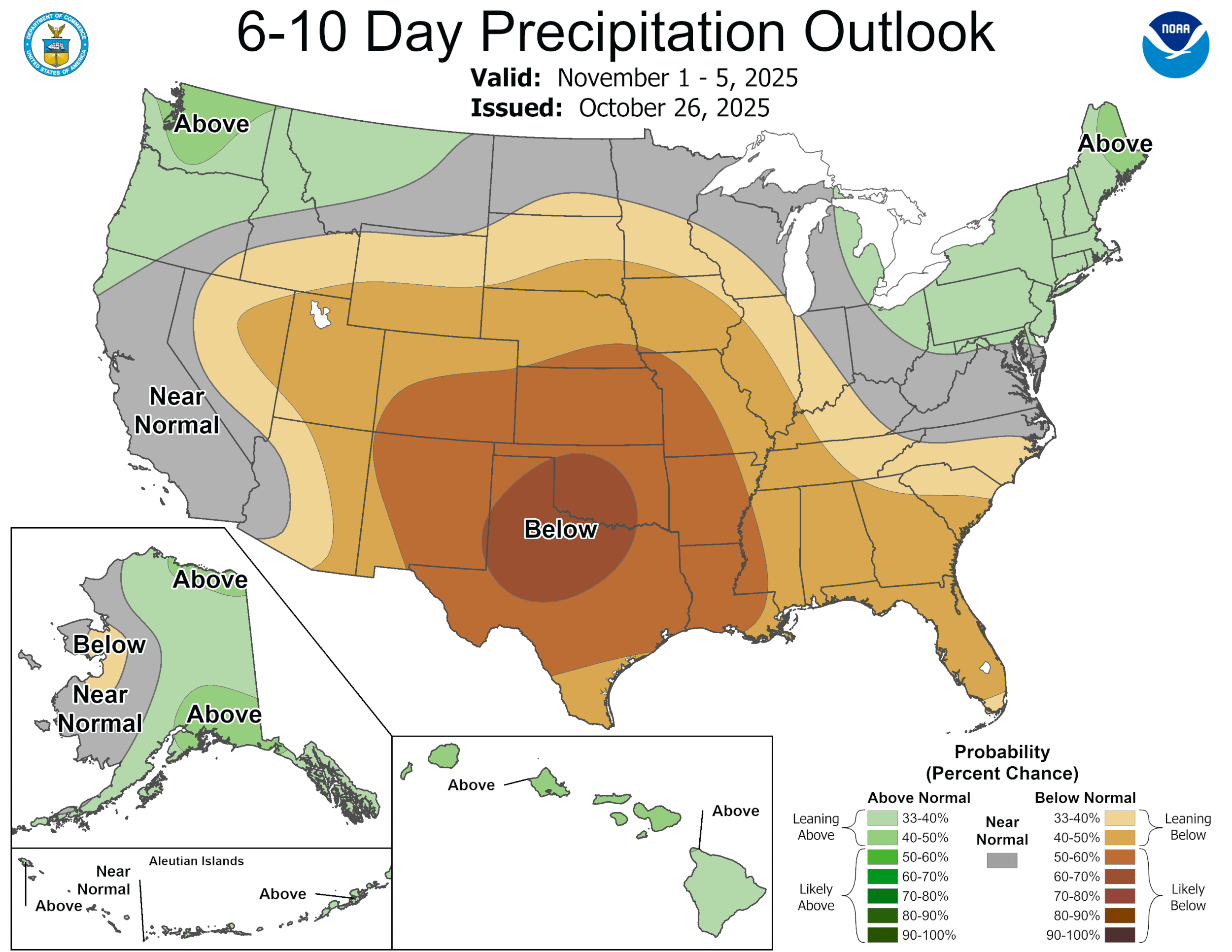
Finally, after over a month into fall, we will see our first real cold front of the season on Tuesday! From the NWS: “A deepening upper level low that will dig south-southeastward from the northern plains into the lower Mississippi Valley will help to bring the strongest front of the season so far across South-Central Texas on Tuesday. Cold air advection in wake of the frontal passage, leads to our first true taste of fall weather throughout our region as soon as Tuesday night. While, there is a subtle warming trend with the returning southerly low-level flow by late week into next weekend, anticipate for at least near to below average temperatures to continue into early November.”
As for rain chances, “Forget about it”. We will likely not see another rain event through the 9th of November and possibly longer. Here is a link to 48hr rainfall totals from the NWS: https://mesonet.agron.iastate.edu/wx/afos/p.php?pil=PNSEWX&e=202510261625
Looking at the tropics…CAT 4 Melissa is churning just south of Jamacia and expected to move across it on Tuesday morning. Below is the latest update and warnings.
1. Jamaica:  Seek shelter now.  Damaging winds and heavy rainfall
today and Monday will cause catastrophic and life-threatening flash
flooding and numerous landslides before potentially devastating
winds arrive Monday night and Tuesday morning.  Extensive
infrastructural damage, long-duration power and communication
outages, and isolation of communities are expected. Life-threatening
storm surge is likely along portions of the southern coast Monday
night and Tuesday morning.

2. Haiti:  Catastrophic and life-threatening flash flooding and
landslides are expected across southwestern Haiti through midweek,
likely causing extensive infrastructural damage and isolation of
communities. Although winds are temporarily decreasing on the
Tiburon peninsula, they could increase again across much of western
Haiti on Tuesday.

3. Dominican Republic: Heavy rainfall through midweek could produce
catastrophic flash flooding and numerous landslides in southern
portions of the country.

4. Eastern Cuba, Southeast Bahamas, and the Turks and Caicos:
Monitor Melissa closely.  There is an increasing risk of a
significant storm surge, damaging winds, and heavy rainfall Tuesday
and Wednesday.  In eastern Cuba, the risk of life-threatening flash
flooding and landslides is increasing. A Hurricane Watch is in
effect for portions of eastern Cuba.
This Update is brought to you by Dietz-McLean Optical. www.dmoptical.com As a family-owned business, our independence, in house lab, great customer service and eyewear warranties, allows us to tailor your eyeglasses, lenses, and fittings: we want you to only expect the best after working with us. With six conveniently located optical shops in San Antonio, Boerne, Marble Falls and Temple, it’s easy to love what you see.

48hr rainfall totals.
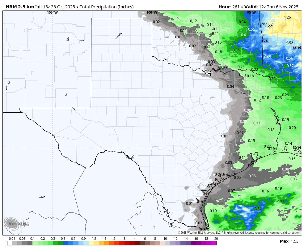
NBM model rainfall forecast through the 6th of November.

Forecast temperatures ahead of the front on Tuesday at noon.

Tuesday temperatures by 9pm.
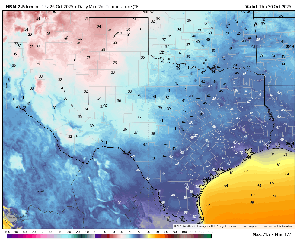
Forecast lows on Thursday.

Halloween Trick or Treat time temperature forecast!
CPC outlooks. Click on images to see them larger.


Monster Melissa.

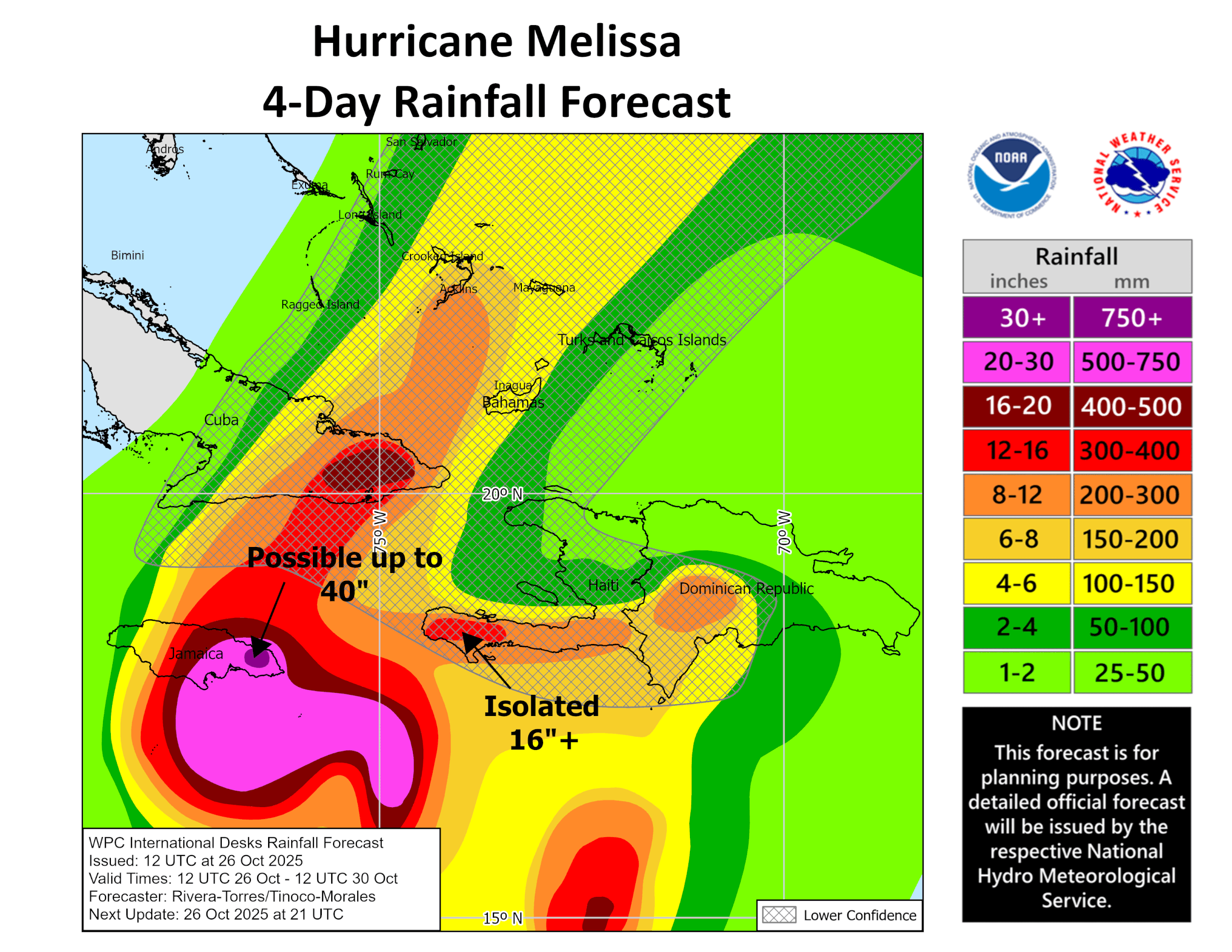
Incredible potential rainfall totals.