A chance for rain, then the strongest front so far this season!
10-25-25. 2:30pm. This post is sponsored by Standby Solutions. With winter just around the corner, and the potential for Polar Vortexes, now is the time to get a quote from our sponsor since it takes only one ice storm to potentially take out your power for days! Synergy Standby Solutions is a trusted provider of sales, maintenance, repairs, and fueling services for standby generators in South Central Texas. We specialize in ensuring your backup power systems remain reliable and fully operational, giving you peace of mind during power outages. With a commitment to excellence and customer satisfaction, our expert team is ready to handle all your generator needs. Learn more at www.synergystandby.com.
Nice to see some additional rain fell this morning and more storms are forecast for this afternoon, although the best odds will be east of 281 and I-37. There is a chance that some of these could become severe. Rain odds evaporate by Sunday behind the front and temperatures will drop into the 50-60’s for lows and highs mainly in the 80’s. On Tuesday, a strong (unfortunately dry) front drills through the state, dropping temperatures by 20 degrees as it moves through! Highs from Wednesday-Friday will drop into the 40’s for lows and highs in the 70’s…we could even see some 30’s in the Hill Country!
Prayers for the folks in eastern Haiti and Jamacia who will be dealing with Hurricane Melissa over the next few days. The latest forecast has Melissa growing into a Cat 4 or 5 storm, then heading directly into the middle of Jamaica.
From the NHC:
1. Jamaica: Melissa’s slow movement will bring a multi-day period of damaging winds and heavy rainfall beginning tonight, likely causing catastrophic flash flooding, numerous landslides, extensive infrastructural damage, long-duration power and communication outages, and potentially prolonged isolation of communities. A life-threatening storm surge is also likely along portions of the southern coast early next week. All preparations should be completed today.
2. Haiti: Catastrophic and life-threatening flash flooding and landslides are expected across southwestern Haiti into early next week, likely causing extensive infrastructural damage and potentially prolonged isolation of communities. Strong winds could also potentially last for a day or more over the Tiburon peninsula.
3. Dominican Republic: Heavy rainfall could produce potentially catastrophic flash flooding and numerous landslides in southern regions.
4. Eastern Cuba, Southeast Bahamas, and the Turks and Caicos: Monitor Melissa closely. There is an increasing risk of a significant storm surge, damaging winds, and heavy rainfall by the middle of next week. In eastern Cuba, the risk of life-threatening flash flooding and landslides is increasing.

This post is sponsored by Standby Solutions. With winter just around the corner, and the potential for Polar Vortexes, now is the time to get a quote from our sponsor since it takes only one ice storm to potentially take out your power for days! Synergy Standby Solutions is a trusted provider of sales, maintenance, repairs, and fueling services for standby generators in South Central Texas. We specialize in ensuring your backup power systems remain reliable and fully operational, giving you peace of mind during power outages. With a commitment to excellence and customer satisfaction, our expert team is ready to handle all your generator needs. Learn more at www.synergystandby.com.

2pm radar.

Current location of our front that should move through by tonight.

Rainfall totals over the past 6 hours.
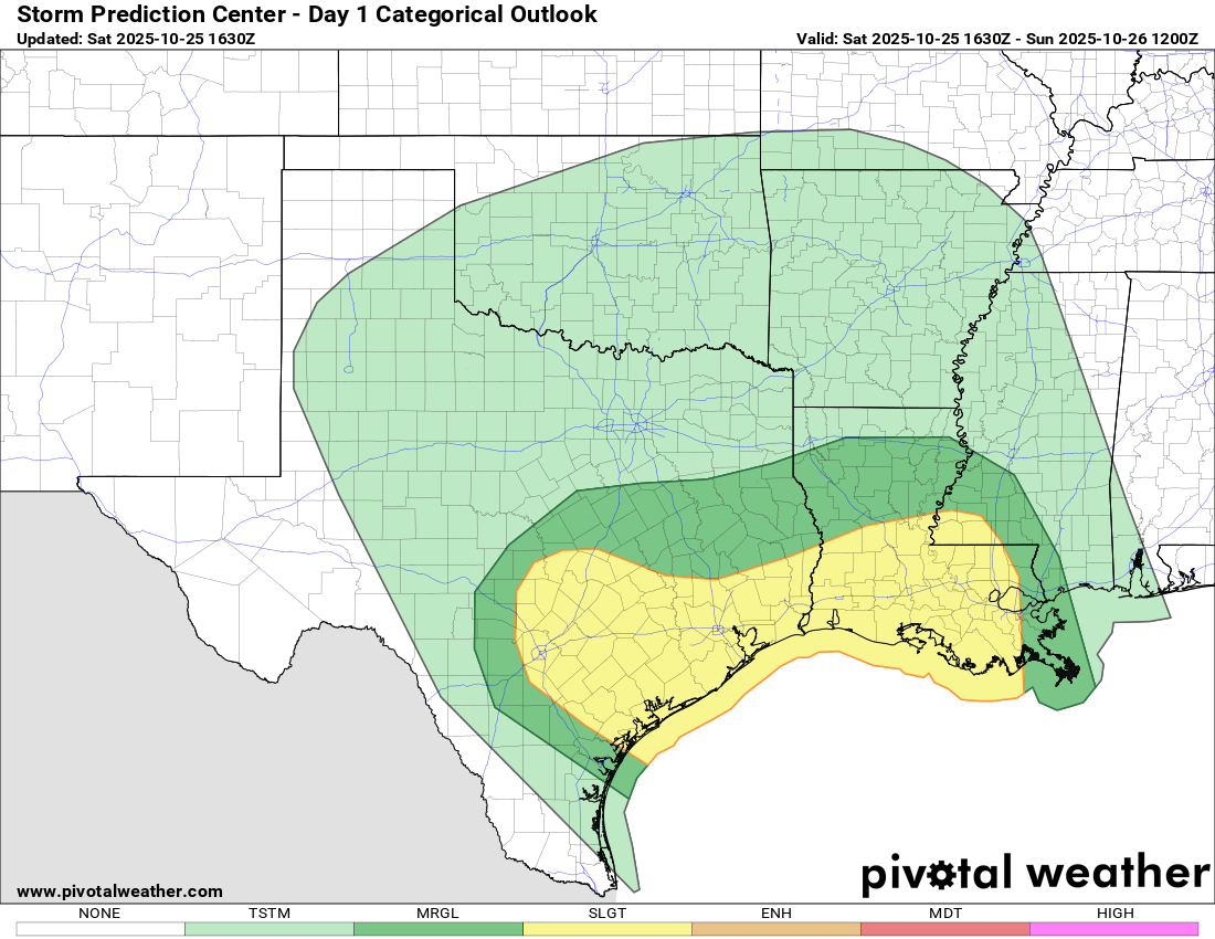

Excessive rain forecast for today.
How much rain the latest models think will fall over the next 12 hours. Click on images to see them larger.


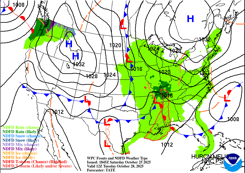
Our strong front will move through the state on Tuesday!
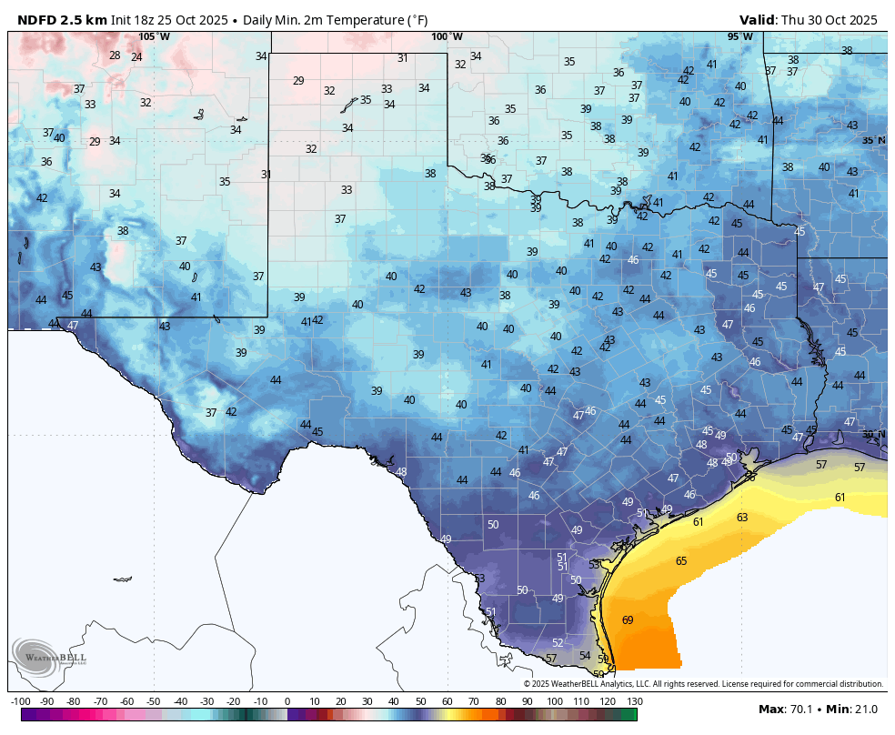
Forecast lows for Thursday.
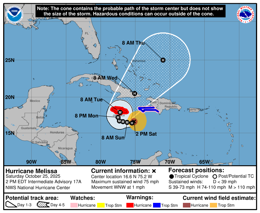
The latest update on Melissa.

Future track forecast for Melissa.