A strong cold front, and unfortunately a Fire Weather Watch issued.
10-27-25. 3pm This Update is brought to you by Blackland Ag Solutions. Boost your farm’s performance with Blackland Ag Solutions. We carry the latest Precision Planting technology to help you plant smarter and grow stronger. Plus, our rugged WAM Affordable Mud Wheels are priced at only $99. With trusted brands like Yetter, Martin, Wearparts 360 Yield Center, Unverferth and more, we’ve got the solutions that keep your operation ahead of the curve. Parts inventories available in Bartlett and Itasca Texas or shipped directly to your farm. Contact us with any of your planter parts needs.
After some fog and clouds this morning, the sun has broken out and temperatures are on the rise. Most areas will heat up into the 80’s and 90’s tomorrow ahead of our strong, dry front that should move through San Antonio between 2-3pm…earlier in the Hill Country and later for south Texas. Temperatures will cool down into the 40’s and 50’s by Wednesday morning and winds will be gusting to 35mph. Those winds and the lack of humidity has prompted the NWS to issue a Fire Weather Watch for Wednesday. Winds will go calm my Wednesday evening and on Thursday morning we will see temps drop into the 30’s in the Hill Country and 40’s in most other locations.
Some of you have asked about whether the NWS has investigated any potential tornadoes that moved through with the storms on Friday night. So far, this is the only report of a tornado from the NWS: “A National Weather Service (NWS) survey team concluded a tornado touched down in eastern Kendall County west of F.M. 3351, or approximately four miles southwest of Kendalia. The tornado moved east through rural Kendall County, producing sporadic tree damage with winds estimated at 65-80 mph (EF-0). The tornado moved east into Comal County, and shortly thereafter crossed the intersection of U.S. 281 and F.M. 306. Five electrical poles and one light pole were brought down near a gas station at this intersection, with peak wind speeds estimated up to 110 mph (EF-1). The tornado continued east-southeast into portions of the Indian Hill subdivision producing sporadic tree, fence, and shingle damage and then east, paralleling F.M. 306 to the south. The tornado crossed Tanglewood Trail, impacting several blocks with concentrated tree damage and shingle damage. Winds were estimated up to 90 mph (EF-1) through this area. The tornado continued east, through northern areas of Mystic Shores, weakening and producing sporadic tree damage. Farther east, the tornado crossed F.M. 306 near Hancock Road and would dissipate shortly thereafter.”
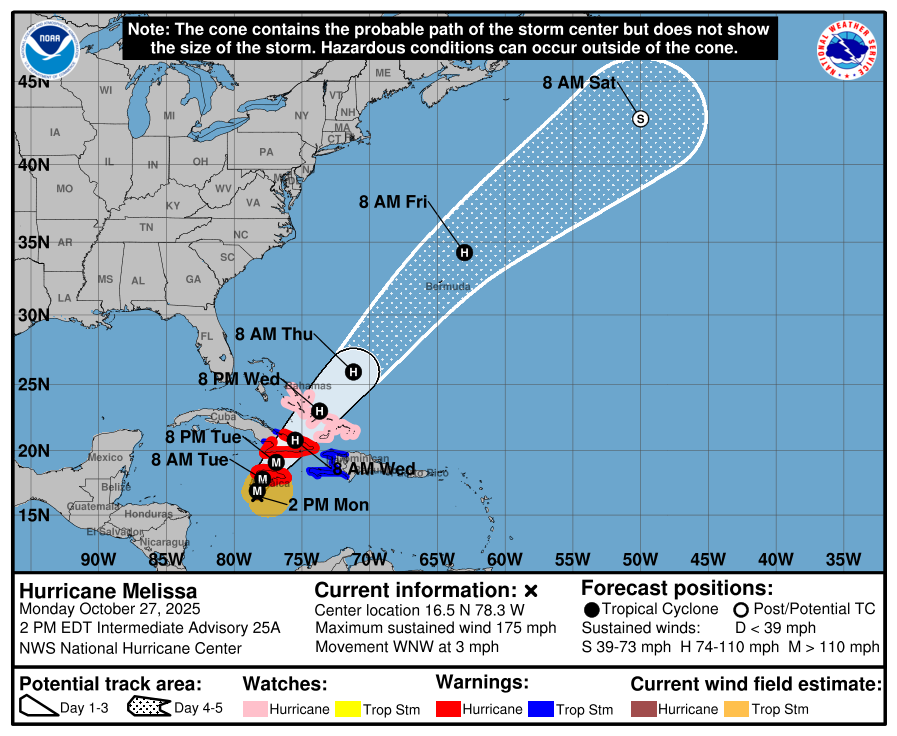
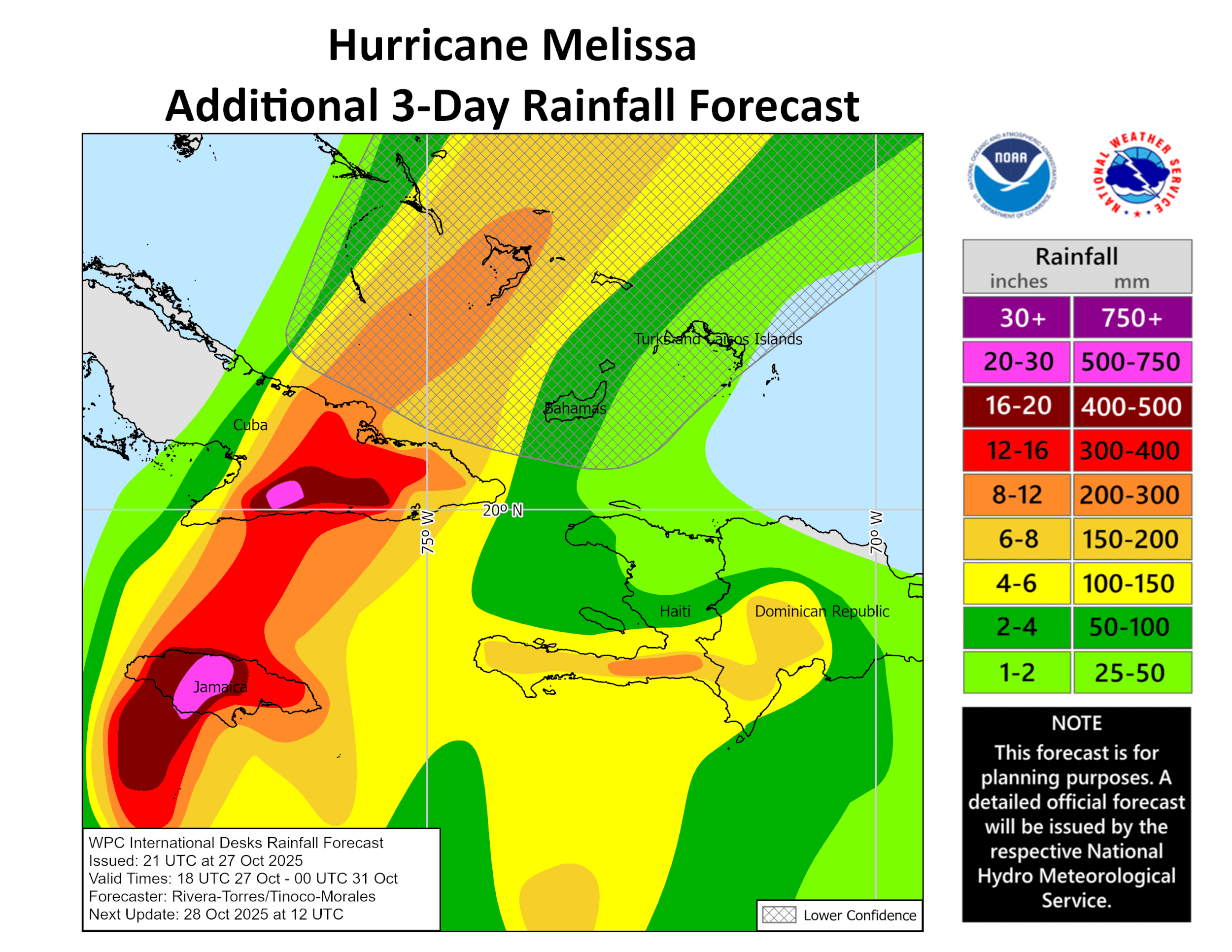
Speaking of storms, we are all about to witness one of the worst hurricanes on record in the Caribbean destroy Jamaica with unbelievably high wind and horrific rainfall over the next 24hrs. As of post time, Melissa has sustained winds of 175mph, making it a strong CAT 5 hurricane! The latest update below.

This Update is brought to you by Blackland Ag Solutions. Boost your farm’s performance with Blackland Ag Solutions. We carry the latest Precision Planting technology to help you plant smarter and grow stronger. Plus, our rugged WAM Affordable Mud Wheels are priced at only $99. With trusted brands like Yetter, Martin, Wearparts 360 Yield Center, Unverferth and more, we’ve got the solutions that keep your operation ahead of the curve. Parts inventories available in Bartlett and Itasca Texas or shipped directly to your farm. Contact us with any of your planter parts needs.
The giant AC unit turns on tomorrow afternoon! AI by Mark
The front should move through San Antonio between 2-3pm tomorrow. Shown are wind speeds.
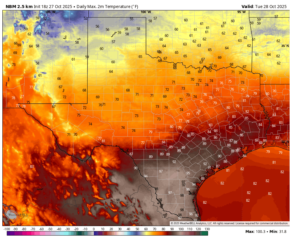
Temperatures ahead of the front will rise into the 80's and 90's.

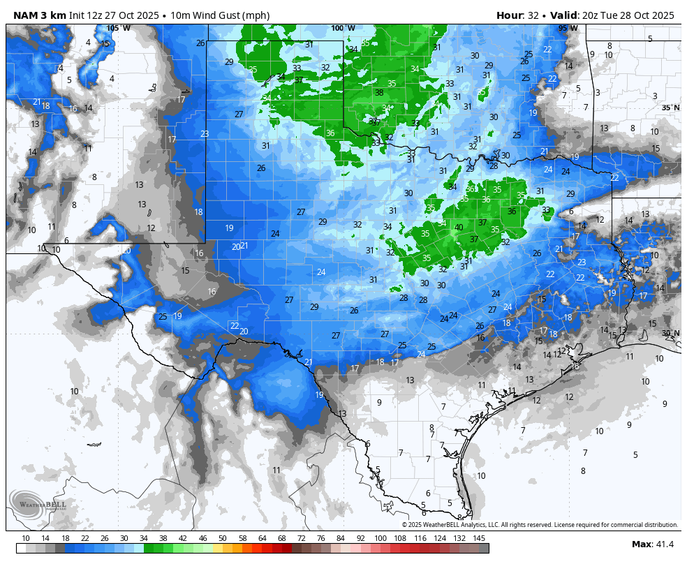
Wednesday wind gusts forecast.

Forecast lows on Thursday.
Fire Weather Watch Report from the NWS. Click on images to see them larger.


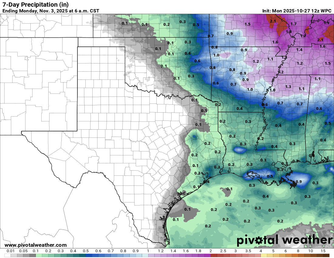
7day rainfall forecast.

Tornado report from the NWS

Selfie of Melissa at 2:30pm

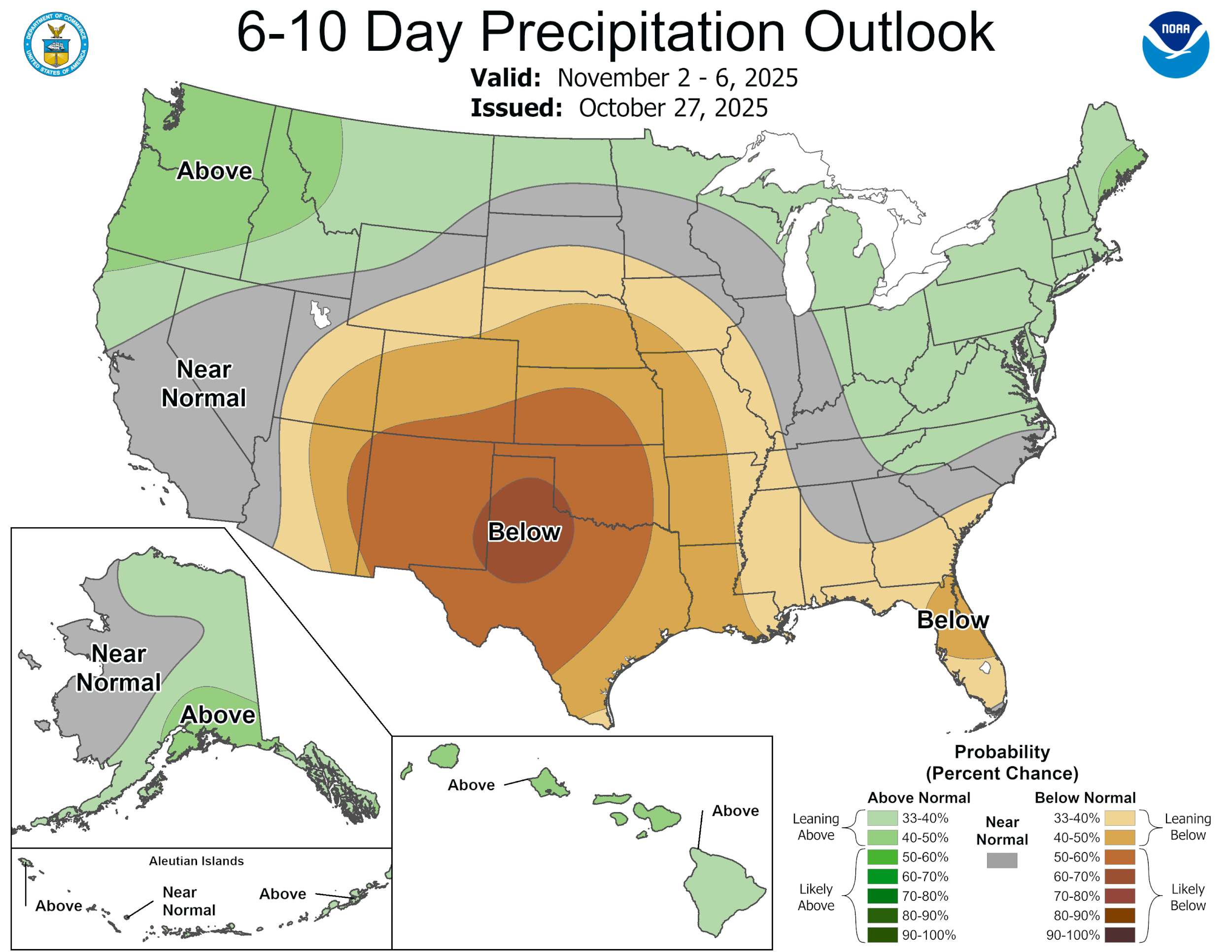
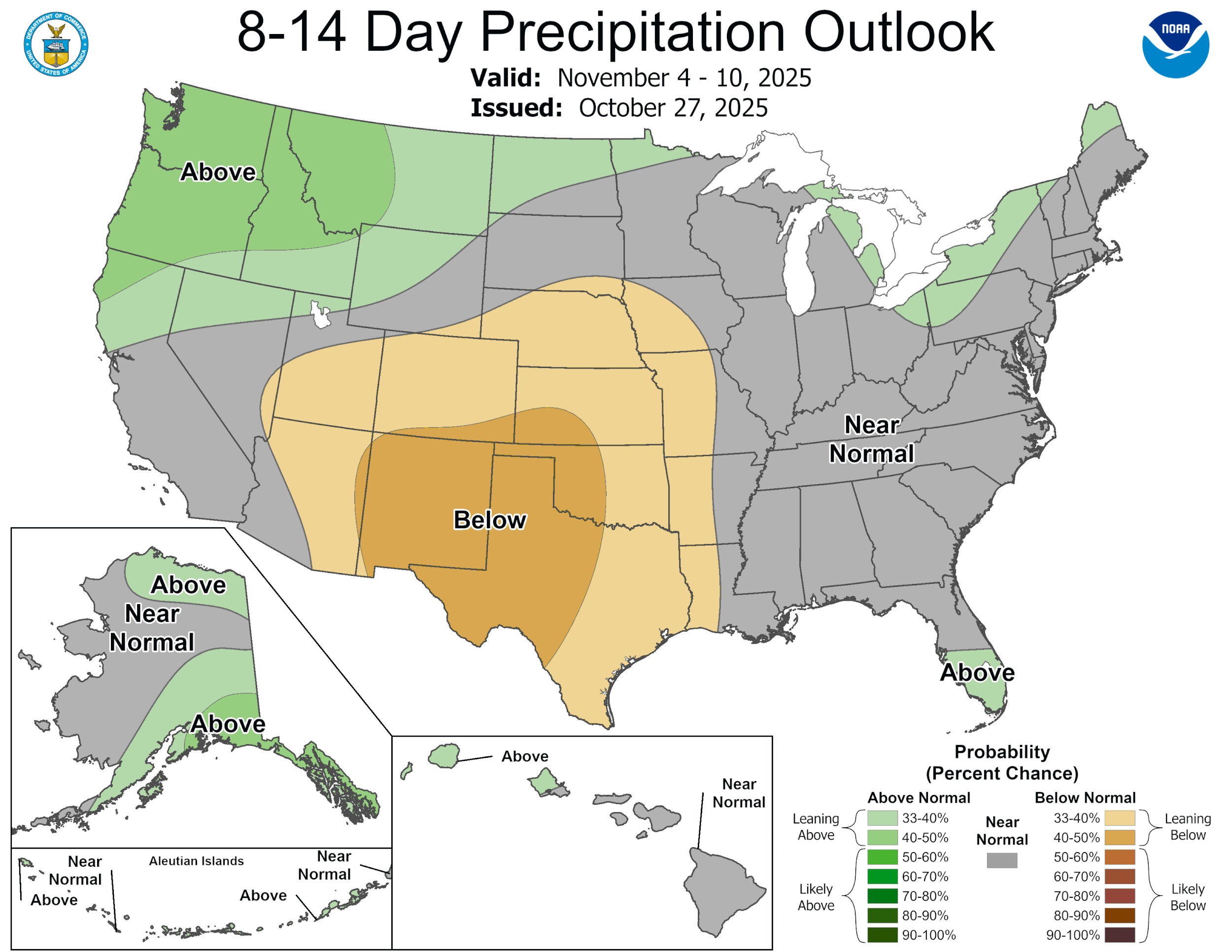
The latest CPC outlooks. Click on images to see them larger.