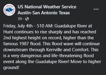
Major flooding on the Guadalupe River!
7-4-25. 8:35am. This Rainfall Roundup is brought to you by Dietz-McLean Optical. www.dmoptical.com As a family-owned business, our independence, in house lab, great customer service and eyewear warranties, allows us to tailor your eyeglasses, lenses, and fittings: we want you to only expect the best after working with us. With six conveniently located optical shops in San Antonio, Boerne, Marble Falls and Temple, it’s easy to love what you see.
While the rain bullseye location was always in doubt from the short-range models last night, they continued to forecast the potential for some major flooding in the Hill Country and that’s exactly what happened in the Kerrville and Menard areas where COCORAHS reports of over 9 inches near Hunt and the NWS remote gauges report 9-14 inches between Menard and Mason! The MCS (mesoscale convective system) that caused this event is still dropping lots of rain over the same area as this system slowly moves SE. We could see some additional heavy rain in and near San Antonio later this morning and into the afternoon.
Below are the latest COCORAHS and NWS rainfall totals so far. The flood watch has been extended through 1pm today. On a positive note, this flood should come close to filling Canyon Lake and if the storms move south into Bandera County, should help Medina Lake.
If you are in one of the flood areas, please share any images or rainfall updates with us. I hope none of you had to be evacuated or saw flooding issues at your homes.
Mark

This Rainfall Roundup is brought to you by Dietz-McLean Optical. www.dmoptical.com As a family-owned business, our independence, in house lab, great customer service and eyewear warranties, allows us to tailor your eyeglasses, lenses, and fittings: we want you to only expect the best after working with us. With six conveniently located optical shops in San Antonio, Boerne, Marble Falls and Temple, it’s easy to love what you see.


Flooding along the Guadalupe River in Kerrville. Screen capture from the Kerrville Town Hall Facebook site.

8:30am radar shows storms are slowly moving SE.

24hr rainfall totals from the NWS and COCORAHS. Click on images to see them larger.


The latest HRRR model is forecasting more rain over the next 24hrs.