It could get nasty this afternoon and evening!
5-26-25. 3pm A perfect time to check out our sponsor! This Update is brought to you by Synergy Standby Solutions. Synergy Standby Solutions is a trusted provider of sales, maintenance, repairs, and fueling services for standby generators in South Central Texas. We specialize in ensuring your backup power systems remain reliable and fully operational, giving you peace of mind during power outages. With a commitment to excellence and customer satisfaction, our expert team is ready to handle all your generator needs. Learn more at www.synergystandby.com.
Before I start this post, I just want to honor all of our fallen heroes and thank them for protecting our freedoms on Memorial Day.
Great to see that some of our western counties got some bonus rain overnight!
THE NATIONAL WEATHER SERVICE HAS ISSUED TORNADO WATCH 331 IN
EFFECT UNTIL 10 PM CDT THIS EVENING FOR THE FOLLOWING AREAS IN TEXAS THIS WATCH INCLUDES 20 COUNTIES IN SOUTH CENTRAL TEXAS
ATASCOSA BANDERA BEXAR
BLANCO BURNET COMAL
EDWARDS FRIO GILLESPIE
GUADALUPE HAYS KENDALL
KERR LLANO MEDINA
REAL TRAVIS UVALDE
WILSON ZAVALA
THIS INCLUDES THE CITIES OF AUSTIN, BANDERA, BLANCO, BOERNE, BURNET, CRYSTAL CITY, FLORESVILLE, FREDERICKSBURG, HONDO, KERRVILLE, LEAKEY, LLANO, NEW BRAUNFELS, PEARSALL, PLEASANTON, ROCKSPRINGS, SAN ANTONIO, SAN MARCOS, SEGUIN, AND UVALDE.
If you’ve been procrastinating about cleaning out your garage, today would be the day to make it happen! There is a very good chance that severe storms will form this afternoon in the Hill Country along outflow boundaries from this morning’s storms, then move south into Austin, San Antonio and potentially points to the south of HWY 90 and I-10 East tonight. Hail, high winds and even a tornado are possible with these storms. There is also a chance for excessive rain today-tomorrow for much of south-central Texas. These storms will not only be severe, but could quickly drop 2-4 inches of rain in a short period of time. As always, please tune into your NOAA weather radio or emergency apps for specific warnings for your location. I will be updated this potentially severe outbreak with radar and watches through the afternoon.
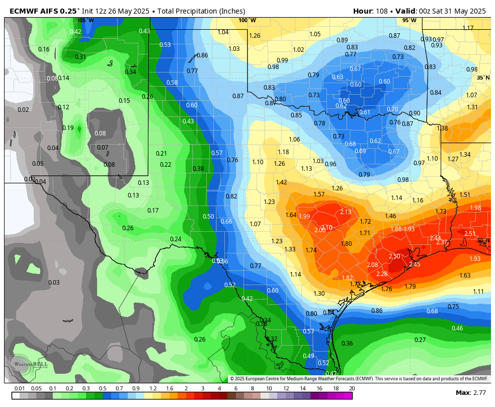
Depending on where the front ends up, rain chances will continue through the rest of this week. The best odds for severe weather will be today and tomorrow.
If storms impact your backyard, feel free to share images and videos with us!
Mark

A perfect time to check out our sponsor! This Update is brought to you by Synergy Standby Solutions. Synergy Standby Solutions is a trusted provider of sales, maintenance, repairs, and fueling services for standby generators in South Central Texas. We specialize in ensuring your backup power systems remain reliable and fully operational, giving you peace of mind during power outages. With a commitment to excellence and customer satisfaction, our expert team is ready to handle all your generator needs. Learn more at www.synergystandby.com.

Remembering all of our heroes who gave their lives for our freedom! AI by Mark


Rainfall totals from last night’s storms.

HRRR future radar forecast for this afternoon and evening.
The latest update from the NWS on our potentially severe weather this week. Click on images to see them larger.


How much rain these models think will fall from today through Friday. Click on images to see them larger.