Flood Watch now in effect.
11-18-25. 3pm. This post is sponsored by Standby Solutions. With the potential for severe storms later this week, now is the time to get a quote from our sponsor since it takes only one storm to potentially take out your power for days! Synergy Standby Solutions is a trusted provider of sales, maintenance, repairs, and fueling services for standby generators in South Central Texas. We specialize in ensuring your backup power systems remain reliable and fully operational, giving you peace of mind during power outages. With a commitment to excellence and customer satisfaction, our expert team is ready to handle all your generator needs. Learn more at www.synergystandby.com.
From our SA-Austin NWS: “A storm system is expected to move from the four corners region into the Southern Plains Wednesday night into Thursday night, bringing with it the potential for pockets of heavy rainfall across South Central Texas through this period. As such we have opted to issue a Flood Watch from 12am Thursday through 6am Friday. Expect rainfall amounts of 1 to 3 inches with isolated totals up to 6 inches in the watch area. The most likely area for excessive rain Wednesday night will be the Southern Edwards Plateau and western Hill Country.”
As I have been mentioning over the past few days, this system (a cool front and trough combo) rain odds and totals look decent for anyone living along and north of HWY 90 and I-10 east, but not so great if you live to the south. For you guys, your best chances will come over the weekend and possibly into next week as a couple more rainmakers could move through.
As far as cold weather goes, that is getting a little more interesting, with the latest GFS and Canadian models forecasting some arctic air moving down on or around Thanksgiving day. The Euro is chiming in as well, but delaying the cold air until after Thanksgiving.
We could have a cold December in front of us if the folks at Severe Weather Europe are correct: “Winter 2025/2026 is around the corner, and the latest forecast data shows cold and snow to start the season in December in the United States, Canada, and Europe. Long-range indications suggest the potential for cold events to persist into January, following a Stratospheric Warming event and the collapse of the Polar Vortex.” This is certainly something I will be tracking!
Mark

This post is sponsored by Standby Solutions. With the potential for severe storms later this week, now is the time to get a quote from our sponsor since it takes only one storm to potentially take out your power for days! Synergy Standby Solutions is a trusted provider of sales, maintenance, repairs, and fueling services for standby generators in South Central Texas. We specialize in ensuring your backup power systems remain reliable and fully operational, giving you peace of mind during power outages. With a commitment to excellence and customer satisfaction, our expert team is ready to handle all your generator needs. Learn more at www.synergystandby.com.

Some of you actually recorded some light rain this morning.
Situation report from the NWS on our upcoming rain event. Click on images to see them larger.


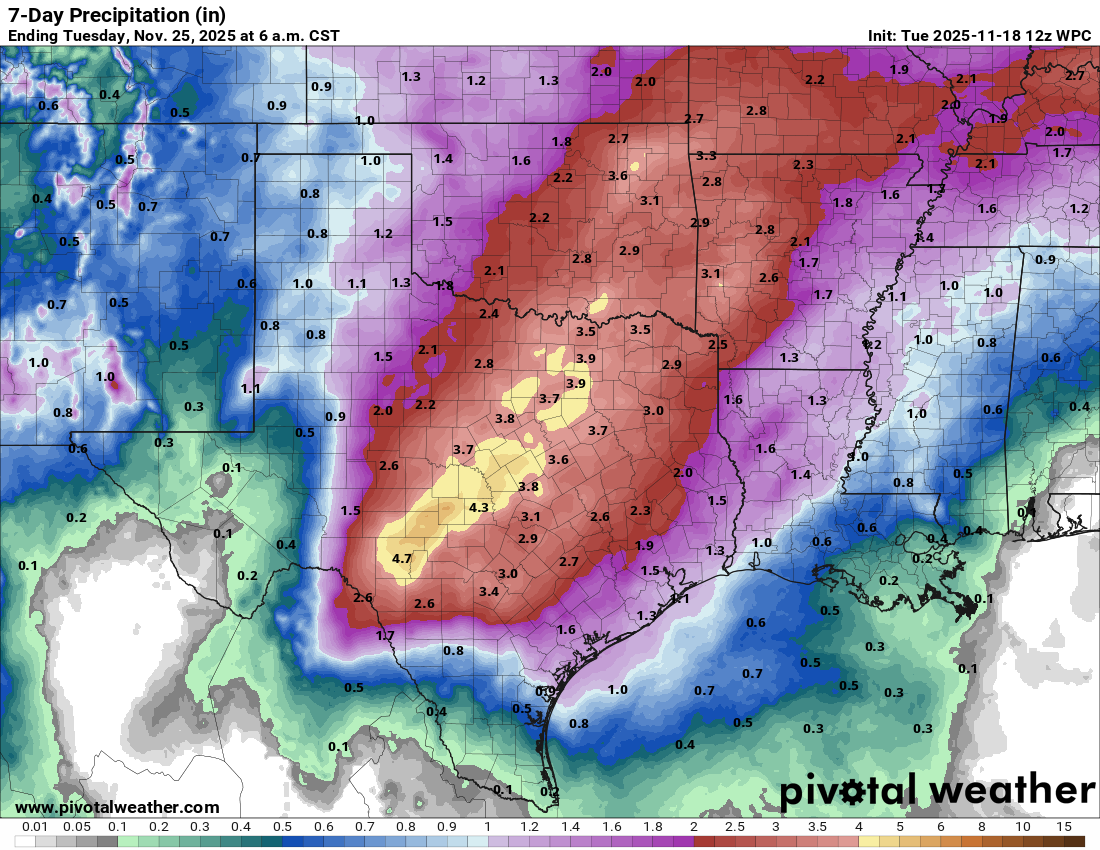
7day rainfall forecast from the NWS.
How much rain the latest models think will fall from Weds through the weekend. Click on images to see them larger.


