But wait, there’s more!
7-14-25. 4pm. This update is brought to you by Dietz-McLean Optical. www.dmoptical.com As a family-owned business, our independence, in house lab, great customer service and eyewear warranties, allows us to tailor your eyeglasses, lenses, and fittings: we want you to only expect the best after working with us. With six conveniently located optical shops in San Antonio, Boerne, Marble Falls and Temple, it’s easy to love what you see.
I think one lesson we’ve learned this week is that nature is going to do what it wants to, regardless of what the models forecast!
Here is what the NWS is saying this afternoon about our MCV that formed last night and dumped a lot of rain in the western counties! Garner Park has recorded over 8.5 inches of rain and Lost Maples 6.5 inches…no surprise that there is a flood warning for the Frio River.
“An MCV continues to spin near the Mexican border this afternoon. There are isolated showers and thunderstorms from the Rio Grande to Hwy 281. Convection is generally producing moderate rain now. PW (Precipitable Water) in the airmass is still abnormally high, and any stronger updrafts could produce locally heavy rain. These systems tend to be more active overnight when the low level jet strengthens. We are seeing the diurnal reduction which should continue after sunset. This MCV will still be in the region tonight and interact with our very moist airmass. Showers and thunderstorms will continue tonight and Tuesday with locally heavy rain possible. Additional rainfall of 1-3 inches with isolated totals up to 6 inches is possible. We are going to extend the Flood Watch until Tuesday morning and expand it to include all of the I-35 Corridor. Models move the MCV away from our region on Tuesday evening bringing an end to rain chances.”
Well, maybe…now the NHC is watching an area of disturbed weather that may turn into a tropical something later this week in the Gulf. Odds are still low, but even a tropical wave could bring in more flooding rain! I’ll be updating this system daily.

This update is brought to you by Dietz-McLean Optical. www.dmoptical.com As a family-owned business, our independence, in house lab, great customer service and eyewear warranties, allows us to tailor your eyeglasses, lenses, and fittings: we want you to only expect the best after working with us. With six conveniently located optical shops in San Antonio, Boerne, Marble Falls and Temple, it’s easy to love what you see.

3:30pm radar has quieted down, but is expected to light up again tonight.

Where the risk of excessive rain is forecast to occur over the next 12 hours.

.FLOOD WATCH IN EFFECT THROUGH TUESDAY MORNING...
* WHAT...Flooding caused by excessive rainfall continues to be possible.
* WHERE...A portion of south central Texas, including the following
counties, Bexar, Comal, Hays and Medina.
* WHEN...Through Tuesday morning.
* IMPACTS...Excessive runoff may result in flooding of rivers, creeks, streams, and other low-lying and flood-prone locations.
Creeks and streams may rise out of their banks.
* ADDITIONAL DETAILS...
- Locally heavy rain of 1-3 inches with isolated totals up to 6 inches.
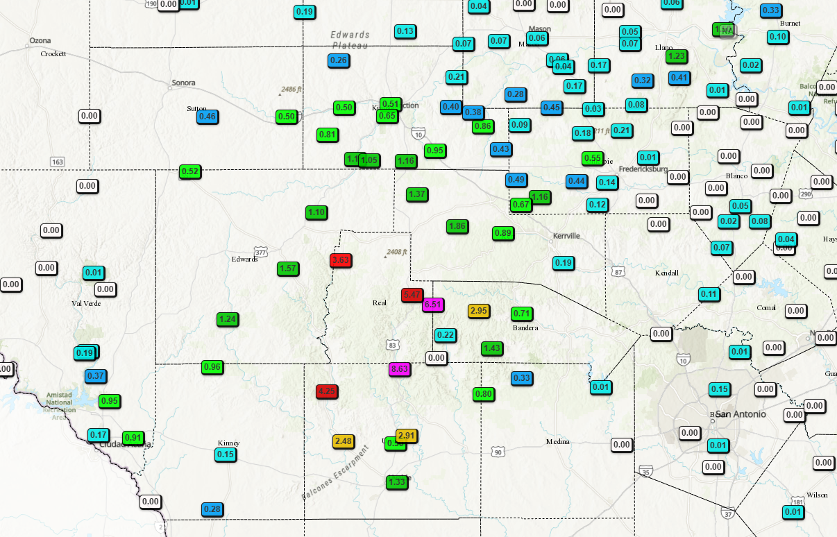
Rainfall totals since midnight!
How much rain these models are forecasting through Tuesday. Click on images to see them larger.


Northeastern Gulf:
An area of low pressure located offshore of the east coast of
Florida is producing disorganized showers and thunderstorms. This
disturbance is forecast to move westward across Florida during the
next day or so, and into the northeastern Gulf by late Tuesday.
Environmental conditions appear favorable and some gradual
development of this system is possible while it moves westward to
west-northwestward across the northeastern and north-central
portions of the Gulf during the middle to latter part of this week.
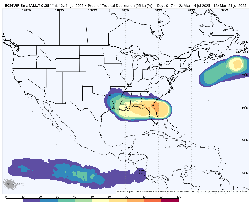
Odds for a tropical depression to form in the next few days and where.